Date:
    May 7, 2018
    (minor revision: May 14-16, 2018)
    (added cross-section visual: June 20-22, 2018)
From:
    Jules Milner-Brage
To:
    Bicycle Advisory Committee
CC:
    Tree Planting (Advisory) Committee,
    Public Transportation Advisory Committee,
    Pedestrian Advisory Committee
CC:
    Peter Furth

Subject:
    Concept bottom line: Restoring the bridle path on Beacon St.,
    per preliminary CAD modeling and ground-truthing study of
    its whole extent in Brookline
- - - - - - - - - - - - - - - - - - - - - - - - -
Since we last spoke about the Beacon St. bridle path restoration
concept at length at a Bicycle Advisory Committee meeting [#N1]---

We received, via Town DPW, a copy of Mass. DOT's CAD model for
the last major renovation of the street (Highway Project 601183,
which was planned 1995-2004 and executed 2005-2009).

I have prepared an updated version of the model to incorporate a
modern incarnation of the bridle path for bicycling (primarily),
per a version of the "shrink to fit" cross-section transformation
that Peter Furth proposed and Jackson Lynch first refined.

And I have also extended the model to incorporate geometry for
items that were missing (per field measurements bolstered by
aerial survey imagery), such as train-stop shelters and plantings
that have been added since that last major renovation was
completed.


For your consideration, as a result of this work:

(1) (below) 'bottom line' summary re. impacts identified through
    whole-street CAD modeling and ground-truthing study,
    plus proposed take-aways [#A0]

(2) (below and attached) explanation of the change modeled:

    [+] revisions made [#A1]

    [+] revised cross-section dimensions [#A2]
            (and attached visual [as per Streetmix])

    [+] details of a median bike path alignment to resolve [#A3]

(3) (attached) plotting output from the model:

        a series of 22x34-in. sheets---
        (revision: May 3, 2018 [minor: May 7-16, 2018]---)

    [+] for screen viewing (as color SVG+HTML)

    [+] for printing (as grayscale PDF)


It has been valuable to work through cross-section dimensions,
path bend radii, route obstructions, etc. within the measured
drafting and analysis environment of AutoCAD.

This has yielded both a higher-resolution and more-complete
illustration of the median bike path concept and a demonstration
of the likely degree of the potential path's geometric fit, along
the whole street, and of specific challenges to its implementation
that are presented by existing conditions.


Sincerely,

Jules


-  -  -  -  -  -  -  -  -  -  -  -  -  -  -  -  -  -  -  -  -  -  -  -  -


[#N1---]

This past July - Oct. 2017, when I (re)introduced the concept and we
honed its framing, in order to facilitate closer study of potential
design and construction strategies.

And then, in Dec. 2017, when Jackson Lynch made a presentation about
work on this study, in collaboration with Peter Furth (advisor in the
Northeastern University Civil Engineering Dept.) and me.
--------------------------------------------------------------------------
[#A0---]
A 'bottom line' summary re. impacts identified through whole-street
CAD modeling and ground-truthing study:
'''
When you search for a way to improve bicycling safety on Beacon St.,
look for a protected two-way path---and the kernel of a linear park---
(presently) hidden in plain sight: the historical "bridle way" along
the median. Next to the row of shade trees on the wide side of the
train tracks, this intrinsic element of the Olmsteds' 1880's design
for the street, and built versions to the 1930's, awaits restoration.
And it seems that this improvement may be achievable with little car
parking loss, while concurrently rendering the street more humane
through shortened cross-walk distances, moderated car travel speeds,
and better access for people to shelter provided by the trees in
the median.
'''
(+) feasible common cross-section and scheme for achieving it:
[+] addition of median protected bike path:
9-ft. wide minimum (and not incl. buffers from parked cars,
1 to 3 ft. depending upon whether from car bumper or door);
... with opportunity for wider path plus a new row of trees via
9 ft. of add'l width that would be freed if median car parking
stalls were reoriented from 45-deg.-angled to parallel (which
incurs an 18% reduction of the total parking supply in a given
altered block)
[+] shortening of crossing distances over wide side for people walking
(and biking):
by 7.333 - 8.333 ft.
[+] NO removal of mature shade trees;
NO alterations on narrow side of street;
NO alteration of outer-edge curbs on wide side
[+] retention of all existing street elements, some in shifted positions:
for people walking across street and along it (from/to median
car parking), for people dis/embarking and waiting for trains,
and for car travel (incl. turn queueing lanes) and parking;
... with the reductions in width (to supplement the space for the
existing wide-side car-door-zone bike lane) essentially only
made in the car elements and, frankly, rather modestly
[+] provision of moderate car traffic calming on wide side:
via trimmed total cross-section space for parallel car parking
plus general travel lanes plus left shoulder that is
essentially the same as the total for these on narrow side;
... and via a trimmed cross-section for the median angled car
parking space that keeps the dedicated maneuvering lane but
slightly changes the parking experience: currently there is so
much space that one generally doesn't even touch the rumble
strip when backing out, whereas in the proposed design, one
often would (but one would still be within the space to the
left/inside of the yellow edge line of the travel lanes);
... (where, for further reference, these trimmed car stalls/lanes
would then be the same as those on the renovated Western Ave.
in Cambridge, which has parallel car parking on both sides of
two general travel lanes with no dedicated maneuvering lane
for either parking row)
[+] nearly zero car parking loss over the whole length of the street,
EXCEPT for a possible moderate reduction in the number of stalls
in two blocks:
18% reduction of total stall inventory per block,
between Center/Webster and Harvard Sts. and
between Charles and Pleasant Sts.;
... BUT in recognition of generally slower car travel speeds
in this area---due to a multitude of cross streets and a
high-volume of walking traffic---a full-width, dedicated
median car parking maneuvering lane may not be needed here
... in which case, if a half-width maneuvering lane was
employed, this potential parking loss could be avoided
... (and, indeed, perhaps an explicit additional speed-limit
reduction---to 20 MPH---would be warranted, like Cambridge
has recently declared in many of their squares)
(+) bike turning movement / walking queueing space scheme---
provide separate, dedicated space in the median for people walking
and biking:
[+] for people biking making turns out of median, via turn queue boxes:
within the envelope of protection from through traffic of the
median curbs, possibly within the roadway of cross streets;
... and possibly further supported by traffic signal phasing
ordered so that car left turns from the wide side "lag" the
the green for the cross street (/ "lead" the green for
bike/car through travel)
[+] for people walking, via space outside of the path of any through-
travel lane---train, bike, or car---to pause before crossing
(+) bike cross-over scheme at wide-side swap and subway-portal locations---
for now, "walk your bike" portage through each of three small areas:
[+] crossing Harvard St. and the train tracks in the west end of
the outbound (east) half of the Coolidge Corner station
[+] crossing the train tracks at the west end of the
Washington Square station
[+] crossing from the outer edge of the street to the median next
to the St. Mary's St. station
(+) preliminary sense of: the scope of necessary construction /
results of a median through-travel obstruction survey:
[+] some addition of pavement is likely needed on the curb bulb-outs
near many intersections,
in order to add median bike path lanes in a distinct position from
(extended/shifted) dedicated space for people waiting in the
median to walk across the car lanes;
(ideally this would be paired with removal of nearly the same
amount of existing concrete paving, which is currently located
further outset of a preferable median bike path alignment and
further inset of extended-position cross-walk waiting areas)
[+] some traffic-signal phase reordering may be needed at some of the
intersections with car left turns from the wide side
[+] (having mentioned, above, all of the things NOT modified---)
some reckoning would be beneficial re. intersection or close
proximity of a good median bike path alignment with some
obstructions,
which have been added over the years since the area next to the
train tracks on the wide side of the street was last used as a
through-travel space:
(+) some newly planted (in last 2-10 years) shrubs and immature
(or non-shade) trees,
(+) a few train-stop shelters positioned unusually further outset
than the norm for the street, and
(+) a few traffic-signal control boxes located in areas then
thought to be "excess space"
A few proposed take-aways:
(+) It would be beneficial to raise awareness of the bridle-path
restoration concept in Town and to engage a broad array of
stakeholders in becoming more familiar with the middle part of
Beacon St. in a new light, so that there is an appreciation of
this particular space's potential value (and benefit to the whole
community) beyond current uses.
E.g.: via demonstrations of protected bike travel space, and
perhaps "pavement park" programming, by means, say, of reducing or
suspending car parking in the median along a segment of the street
for a day or two of a weekend.
(+) It would be beneficial for the Town to further study the design
engineering, cost, and possible funding of building this
safety/greenway-character improvement to Beacon St.
(+) It would be worthwhile for the Town to strive not to add any new
median obstructions to through-travel along a straighter alignment
(i.e., nearer to the train tracks).
My sense is that this is about awareness of the possibility of
restoring the bridle path, e.g.: among folks maintaining and
making decisions re. tree plantings, traffic signal equipment, and
parking meter equipment; among folks strategizing re. how/where
on-street EV (electrically powered motor vehicle) charging
infrastructure may be added; etc.
- - - - - - - - - - - - - - - - - - - - - - - - -
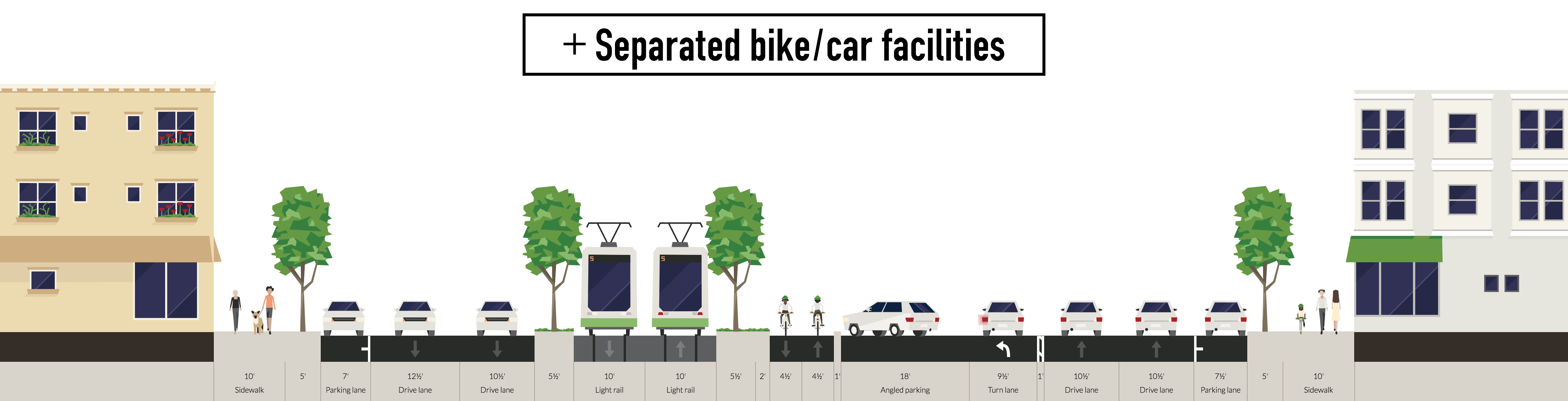
[#A1---]
Revisions made:
on wide side ONLY---
(+) shift car travel + left-turn queueing lanes
and median parking stalls and maneuvering lane outward;
extend median curbs and rumble strip outward:
(in order to provide dedicated space for a median bike path
on this [wide] side, via revised cross-section dimensions [#A2]---)
[+] paint revision for lane/stall shifts
[+] possibly "quick-build" precast wheel-stop curb segments or
flexible delineator posts for curb extensions?
[+] to be coordinated (immediately? eventually?) with shifts of
in-pavement traffic sensors and traffic signal heads on
overhead arms
[+] to be coordinated with strategy for median parking meters
(e.g., just step over the path; switch to more-centralized kiosks)
(+) revise foot/bike path pavement +
curb ramps on median curb bulb-outs:
adding these closer to train tracks,
and (eventually?)
removing them beside existing curbs
and adding them beside newly extended curbs:
(in order to add median bike path lanes in a distinct position
from [extended/shifted] dedicated space for people waiting in
the median to walk across the car lanes [and thus to shorten
cross-walk distances] on this [wide] side---)
[+] possibly "quick-build" asphalt for added path pavement +
asphalt fillet for added curb ramps?
(+) resolve median bike path alignment details:
(see below [#A3])
... i.e.---
altering wide-side widths and across-street positions of street-
space elements between the existing outer- and inner-most curbs
(but possibly retaining the existing median curb lines, for now,
in case these curb movements might be achieved, at first, via
flexible delineator posts or wheel-stop curb segments?)
by performing geometric shifts perpendicular to the street axis
- - - - - - - - - - - - - - - - - - - - - - - - -
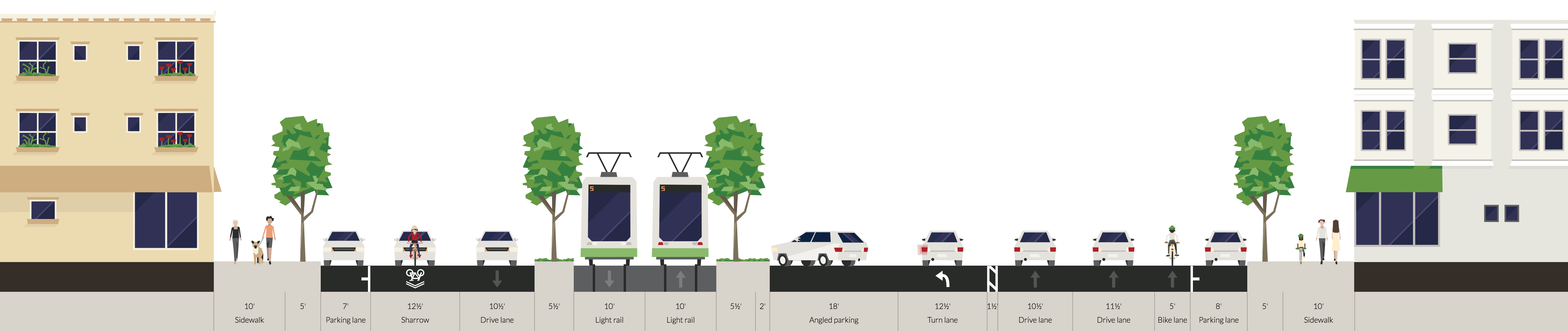
[#A2---]
Revised cross-section dimensions:
on wide side ONLY---
(+) car through-travel and turn-queue lanes:
norm 3.2 m (~ 10.5 ft.);
very occasional absolute min. 3.05 m (~ 10 ft.)
(+) outer-edge parallel car parking:
norm 2.25 m (~ 7.5 ft.), and not-infrequently ~ 0.15 m more;
very occasional absolute min. 2.1 m (~ 7 ft.)
(NB: the norm here [0.3 m (~ 0.5 ft.) larger than perhaps we
would prefer] was chosen so as ensure 0.3 m [~ 1 ft.]
clearance from existing outer-edge curb bulb-outs,
so that none should need to be altered)
(+) outer-edge and median shoulder
(curb bulb-out and rumble-strip shy distance):
0.3 m (~ 1 ft.)
(+) median 45-deg.-angled car parking plus dedicated maneuvering lane:
norm 8.7 m (~ 28.5 ft.);
extremely occasional absolute min. 8.55 m (~ 28 ft.)
(+) median parallel car parking plus dedicated maneuvering lane:
norm 5.3 m (~ 17.5 ft.);
extremely occasional absolute min. 5.15 m (~ 17 ft.)
... plus buffer on curb side:
0.9 m (~ 3 ft.)
(+) median rumble strip
(along outward edge of car parking maneuvering lane,
inset of lane line by aforementioned shoulder/shy distance):
dimension not altered, for now---
1.0 m (~ 3.333 ft.);
extremely occasional absolute min. 0.5 m (~ 1.667 ft.)
(NB: could this, possibly, be narrowed to a new norm of,
e.g., 0.6 m [~ 2 ft.], which would be a reduction
proportional to that done for shoulders [from 0.5 m,
minus 0.2 m]? or could it be removed?)
(+) NEW median bike path:
2.75 m (~ 9 ft.)
... plus buffer from parked cars:
0.3 m (~ 1 ft.) for 45-deg.-angled (front bumpers),
OR 0.9 m (~ 3 ft.) for parallel (side doors)
- - - - - - - - - - - - - - - - - - - - - - - - -
[#A3---]
Details of a median bike path alignment to resolve:
(+) median car parking stall siting:
NO broad removal of stalls, EXCEPT---
[+] between Centre/Webster St. and Harvard St.:
possible loss of 7 stalls (of 16 existing),
due to conversion from 45-deg.-angled to parallel orientation
(because the 1.5 m [~ 5 ft.] of space that elsewhere was
allocated to a car-door-zone [outer-edge] bike lane, here
was allocated to a median sidewalk to/from the Coolidge
Corner train station instead)
(and because the parallel conversion frees more space than
needed to make the new median bike path whole, at 2.75 m
[~ 9 ft.] wide, the excess ~ 1.2 m [~ 4 ft.] yielded is
modeled as allocated to widen that median sidewalk)
BUT if a half-width maneuvering lane was employed, in
recognition of generally slower car travel speeds in this
area, this potential parking loss could be avoided
[+] between Charles St. and Pleasant St.:
possible loss of between 5 and 7 stalls (of 16 existing),
due to the need, it seems, to angle general-purpose car lanes
inward, into the space occupied by the dedicated median car
parking maneuvering lane
(because:
[+] the existing car-door-zone bike lane unceremoniously
ended at the western leg of the Pleasant St.
intersection as the means for blending the wide-
vs. narrow-side width / across-street-position
regimes of the car lanes;
[+] the Pleasant St. 'triangle' people refuge tightly
constrains the car lanes on their right side
[occupying the outer-edge space that just eastward is
devoted to parallel car parking stalls]; and
[+] the outer-edge sidewalk just west of Pleasant St. was
made unusually wide---5.3 m [~ 17.5 ft.], rather than
the norm of 4.6 m [~ 15 ft.])
and going forward, we need to blend the width and across-
street position of the car lanes here---
the space for this could be provided, it seems, by either:
[-] keeping the block's car parking 45-deg. angled and
eliminating the stalls opposite the Pleasant St. triangle
to eliminate the conflict between the general-purpose car
lanes, as they angle, and the dedicated median car parking
maneuvering lane (and to form a new planting and/or people
space beside the new median bike path);
... OR ...
[-] converting the block's car parking to parallel, and
devoting the excess space freed to form a planting buffer
beside the new median bike path (or to form a wider path)
to absorb narrowing from east to west, as the
general-purpose car lanes angle south
the first option is modeled, for now;
BUT if a half-width maneuvering lane was employed, in
recognition of generally slower car travel speeds in this
area, this potential parking loss could be avoided
[+] between Winchester St. and Centre/Webster St.:
loss of 1 stall (of 8 existing),
due to extension of Winchester St. curb bulb-out
(in order to fully protect the angled car parking
maneuvering lane from through-travelers turning from
Winchester St. [which intersects at an ~ 45-deg. angle])
[+] between Washington St. and Westbourne Ter.:
loss of 1 stall (of 5 existing),
due to merging of duplicate car left-turn and dedicated car
parking maneuvering lanes;
BUT 2 new stalls were gained at the *outer edge* of the street
directly opposite (in front of Athan's)
(these stalls were included in the original model, but
have been removed on the actual street at some point
[or were never actually marked], in order, it seems,
to widen and smooth the emergence of the car-door-zone
bike lane here [which is removed in the revised design])
[+] at Corey/Dean Rd. (west end):
loss of 1 stall,
due to a need to clear a mature shade tree that is
planted very close the curb here
[+] at Corey/Dean Rd. (west end):
loss of 1 stall,
due to a need to clear a street light that is located
very close to the train stop platform fence here
[+] at Carlton St. (east end);
at Hawes St. (east end);
at Charles St. (east end);
at Pleasant St. (east end);
between Lancaster Ter. and Mason Path (mid-block);
at Summit Path (mid-block);
between Winthrop Rd. and
Williston Rd. / Tappan St. (mid-block);
between Corey/Dean Rd. and Englewood Ave. (mid-block);
at Ayr Rd. (east end):
likely TEMPORARY loss of 1 stall in each of these locations
(8 stalls, in total, spread broadly along the street),
due to a stall being located incised within a concave space in
the curb bulb-out at each of these locations
(that cavity becomes inaccessible to the maneuvering lane,
once the lane is shifted outward, until the bulb-out's
curb is rebuilt so that the parking cavity is also shifted
outward to match the altered stall and maneuvering-lane
positions)
(+) median train stop shelter siting:
where the shelter is far outset from the platform at an
unusually great distance (compared to the norm at most
stations including, e.g., the major ones: Coolidge Corner,
Washington Square, and St. Mary's St.):
should be shifted inward slightly---
[!] east end of Powell/Kent St.
[!] west end of St. Paul St.
[+] at mid-bock between Winthrop Rd. and Williston Rd. / Tappan St.
possibly should be shifted inward slightly
(but only beneficial if tree plantings were revised)---
[?] west end of Corey/Dean Rd.
[?] west end of Englewood Ave.
(+) median traffic signal control box siting:
where the control box is closely outset from the 'core'
planting + train catenary pole + etc. strip (directly next
to the train tracks):
likely MUST be shifted inward (or outward or rotated)---
[!] west end of Pleasant St.
[!] east end of Harvard St.
should be shifted inward (or outward or rotated)---
[!] west end of St. Mary's St.
(plus 2 new street lights and 1 new car parking meter kiosk)
[+] west end of Carlton St.
(plus 1 new street light and 1 new car parking meter kiosk)
[+] east end of Hawes St.
[+] east end of Centre/Webster St.
[+] at Mason Path
[+] west end of Westbourne Ter.
(actually 1 new street light)
[+] east end of Englewood Ave.
(+) median plant siting:
[-] in 'core' strip,
directly next to train tracks:
locus of almost all shade trees in the median,
with a good number being mature:
NO conflict / NO change needed
[+] in 'bulb-out' beds,
outset from train tracks, in place of car parking:
some being bushes, most of the rest seeming to be low,
non-shade tree varieties, with almost all seeming to
have been planted in last 2-10 years since last major
renovation of the street:
likely MUST be shifted outward---
(!) east end of Powell/Kent St.: 9 new low trees
(!) east end of St. Paul St.: 9 new bushy trees
should be shifted outward---
(+) east end of Carlton St.: 2 new trees
(+) west end of Carlton St.: 2 new trees
(+) east end of Hawes St.: 5 new low trees
(+) west end of Hawes St.: 6 new low trees
(+) east end of Charles St.: 1 new tree
(+) west end of Charles St.: 2 new bushes
(+) west end of Pleasant St.: 2 new bushy trees
(+) east end of Harvard St.: 1 new tree
(+) east end of Centre/Webster St.:
1 new tree (ailing)
(+) west end of Centre/Webster St.:
7 new bushy trees (actually issue for walking path)
(+) west end of Winchester St.: 3 new low trees
(+) at Summit Ave.: 2 new bushy trees
(+) east end of Marion St.: 2 new bushy trees
(+) west end of Marion St.: 11 new low trees
(+) at mid-block between Mason Path and Fairbanks St.:
3 new low trees
(+) at Fairbanks St.: 8 new low trees
(+) at Summit Path: 1-2 new trees
(+) east end of Westbourne Ter.: 3 new trees
(+) east end of Winthrop Rd.: 7 new bushy trees
(+) west end of Winthrop Rd.: 2 new bushes
(+) at mid-bock between Winthrop Rd. and Williston Rd. / Tappan St.:
2-4 new bushy trees
(+) east end of Williston Rd. / Tappan St.: 4 new bushes
(+) west end of Williston Rd. / Tappan St.: 2 new bushes
(+) at mid-bock between Corey/Dean Rd. and Englewood Ave.:
2 new trees
(+) east end of Englewood Ave.: 1 new tree
(+) west end of Englewood Ave.: 2 new low trees
(+) west end of Strathmore Rd.: 1 new low tree
(+) traffic signal phase ordering or actuation:
[+] at intersections where a car left turn from the wide side
is permitted (from a queueing lane in the median):
possibly MUST be reordered so that the wide-side car left turn
phase "lags" the green for the cross street (a.k.a. "leads"
the green for straight-through bike/walk/car travel)---
(in order to protect median bike turn queueing boxes located
in the lanes of cross-streets, within the along-street
protective envelope of the median curb bulb-outs---)
(+) Powell/Kent St.:
WIDE-side car left turn = LAGGING + concurrent
(+) St. Paul St.:
narrow-side car left turn = leading + concurrent;
WIDE-side car left turn = LAGGING + concurrent
(+) Englewood Ave.:
narrow-side car left turn = leading + concurrent;
WIDE-side car left turn = LAGGING + concurrent
NO conflict / NO change needed---
(?) Hawes St.:
wide-side car left turn = leading + concurrent;
narrow-side car left turn = lagging + concurrent
... BUT what about "pre-emption phasing and priority" here?
seems like its ordering might swap the wide side to be
lagging + concurrent?
(-) Charles St.:
narrow-side car left turn = leading + concurrent
(-) Centre/Webster St.:
narrow-side car left turn = leading + concurrent
(-) Marion St.:
wide-side car left turn = leading + concurrent;
narrow-side car left turn = lagging + concurrent
(-) Corey/Dean Rd.:
wide-side car left turn = leading + concurrent
[?] at intersections where car travel is not permitted where bike
travel should be, and/or actuation of non-car (walk + bike)
phases is disconnected from (not automatically concurrent with)
car phases:
may require change to make non-car phase automatic and/or
addition of push-button for non-car phase request---
(?) Charles St.:
south-bound travel lacks car signal, and is on opposite
end of intersection as the sole south-bound cross-walk
(?) Pleasant St.:
north-bound travel is only after walk push-button request
(?) Winchester St.:
south-bound travel with cars is disconnected from
south-bound walk (which is only after push-button request)